At iSDA, we have created the first field-level soil map for Africa, which estimates over twenty soil properties across the entire continent. These properties range from chemical factors, like aluminium and pH levels, to physical factors, such as clay content and slope angles, and soil nutrients like potassium and zinc. Our soil map at iSDAsoil stands out as the sole resource that predicts soil properties at 30 m resolution for the entire continent. This sets it apart from global soil maps, which typically offer resolutions of 250 m. Our higher spatial resolution enhances the precision of our predictions.
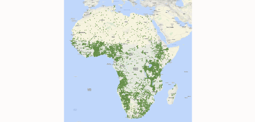
A map showing the locations of all the soil samples that we used to create the field- level soil map
It is infeasible to collect soil samples from every location in Africa, so we make estimates by calibrating the limited amount of ground measurements with readily available data from satellite imagery that covers the entire continent. To create our estimates, we gathered all the available soil data that had been previously collected across Africa, gaining over 130,000 analysed soil samples, with much of this data having been collected under the Africa Soil Information Service (AfSIS). The satellite-derived data includes annual rainfall and temperature, and various properties of the land surface such as vegetation cover and elevation. Using machine learning, we trained a model to learn the relationship between the remote sensing data and the measured soil properties. Once we have trained our model, we then use it to estimate soil properties for every location in Africa. We also include a measure of the prediction error, which estimates the accuracy of the maps.
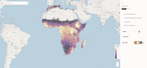
Our iSDAsoil field-level soil map which offers open access soil data to everyone
A lot of the data that went into creating our field-level soil map at iSDAsoil was created by grant-funded research projects. We believe that the right thing to do is to make this data open-access and free to use and have tried to make the iSDAsoil platform as accessible as possible by displaying it on as many different platforms as we can.
We have the open-access data displayed on our website which will be kept up to date and have made the user experience as simple as possible. We give as much background information as we can through our technical information page featuring an overview of our technical workflow, an FAQ section to answer any queries, and the release of published papers, which go into even greater detail about our data and research. Additionally, we offer a free API, which allows software developers to query our soil data by location.
Our open access soil health data is also available on a variety of platforms outside of our website for anyone to analyse, including Google Earth Engine, and the Amazon Web Services Registry of Open Data (AWS RoDA) where users can also download the entire maps. As part of our continued commitment to open access, we have also made public much of the soil analysis data used to train our models. At iSDA, we want to encourage the sharing of additional soil data which can further enhance our database. If we can get more data, we can create new versions of the map, bringing them up to date and improving accuracy. We have soil data from across Africa, but the amount of data received is stronger in some locations than in others. So, one of the goals of making it open access is to create a cycle of people sharing soil data to improve the maps that can benefit everyone in the long term.
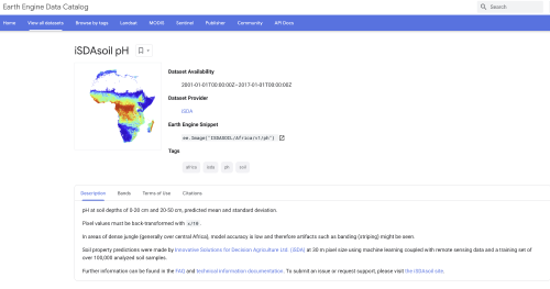
One of our open-access data sets on soil pH levels available on Google Earth Engine
This data is useful for researchers and scientists, but end users including farmers require the follow-up steps needed to translate the data into more effective agronomic management. Our Fertility Capability Classification analysis tool converts our soil map into more actionable information, classifying areas based on constraints to soil fertility, for example, low mineral levels, soil thickness and terrain elevation, and what elements would need adjusting so that a farmer can expect good yields in the future.
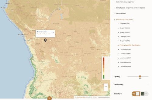
Our Fertility Capability Classification analysis tool highlighting constraints in a particular location (sloping terrain, aluminium toxicity, and low potassium levels), which could affect soil health and crop yield
Soil maps are important as they can improve local knowledge of soil fertility which can encourage sustainable farming and improved agricultural management. Soil health data is one of the most crucial factors in determining crop yields for farmers as having good, healthy soil encourages healthy crops which increases the potential for high yields. These high yields can result in more sales and improved livelihoods. When people are not aware of soil health and potential constraints, it can lead to incorrect soil management which can have long-term negative impacts on crop health and yield.
The main way we utilise our soil data, is to make site-specific fertiliser recommendations with Virtual Agronomist, our tailored advisory service, across a range of countries and crops in Africa. With iSDAsoil, farmers can see where soils are deficient in specific nutrients and apply a fertiliser to counteract those deficiencies. Without knowledge of soil health, farmers can often apply the wrong type or amount of fertiliser which can have negative impacts on their finances. Democratising soil information benefits all chain actors in the agricultural sector, giving them knowledge that would otherwise be difficult or costly to acquire. Alternatives such as soil testing, are expensive and take a longer amount of time, compared to using free soil data and analysis tools. Fertiliser misuse can also create imbalances in the soil supply of nutrients to crops. Good soil health comes from soil fertility awareness, allowing farmers to manage their soil correctly and improve their soil health in the long term, something iSDAsoil can help with.
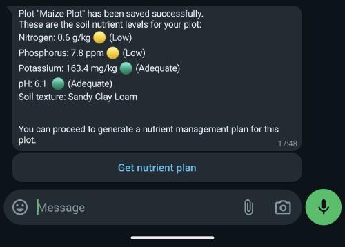
Virtual Agronomist showing a farmer's soil properties before generating a nutrient plan
In addition to helping farmers and the agricultural sector, soil health data can also be used to help solve other prominent issues. Our data was recently used by scientists to map malaria exposure levels of African citizens living in towns and cities. Soil pH is a factor which affects the habitats of the Anopheles mosquito which transmits malaria. The researchers and scientists who were a part of this study used our open data from iSDAsoil to improve their predictive models. Malaria is at an all-time high in Africa and research on transmission is therefore a public health priority, something that we were proud to be able to contribute to.
Soil data also provides valuable information regarding the wider environment and climate. A lack of open access soil data can lead to poorly managed soil where people are applying the wrong fertilisers and not using enough organic matter which can damage soil health. As a result, the soil can release carbon into the atmosphere rather than take it out, leading to increased problems with climate change. Poorly managed soils can also lead to environmental damage due to excess fertiliser runoff which can have a detrimental impact on rivers, lakes, and oceans, destroying marine and aquatic ecosystems. If farmers know more about their soil using the data maps, then they can establish good agronomic management which can benefit the environment rather than harm it.
At iSDA, we know the importance of soil health data and its impact on farmers, their community, and the wider environment. Our open access data gives this vital knowledge to people everywhere and we plan to continue to update our predictions based on new data as time goes on.
Find out more information on iSDAsoil here
View the raw data on Amazon Web Services and Google Earth Engine